
Make a donation
Gear up for your next adventure:
As an Amazon Associate, this site earns from qualifying purchases at no extra cost to you.
Dupont Center topographic map
Click on the map to display elevation.
Make a donation
Gear up for your next adventure:
As an Amazon Associate, this site earns from qualifying purchases at no extra cost to you.
About this map
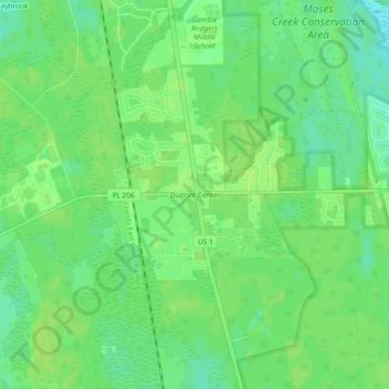
Name: Dupont Center topographic map, elevation, terrain.
Location: Dupont Center, Saint Johns County, Florida, United States (29.73636 -81.33313 29.77636 -81.29313)
Average elevation: 9 m
Minimum elevation: 1 m
Maximum elevation: 12 m
Make a donation
Gear up for your next adventure:
As an Amazon Associate, this site earns from qualifying purchases at no extra cost to you.
Other topographic maps
Click on a map to view its topography, its elevation and its terrain.
Castillo de San Marcos
United States > Florida > Saint Johns County > Saint Augustine
Average elevation: 2 m
Julington Creek Plantation Park
United States > Florida > Saint Johns County > Fruit Cove
Average elevation: 7 m
Twelve Mile Swamp Conservation Area
United States > Florida > Saint Johns County
Average elevation: 8 m
Make a donation
Gear up for your next adventure:
As an Amazon Associate, this site earns from qualifying purchases at no extra cost to you.