
Predigtstuhl topographic map
Click on the map to display elevation.
About this map
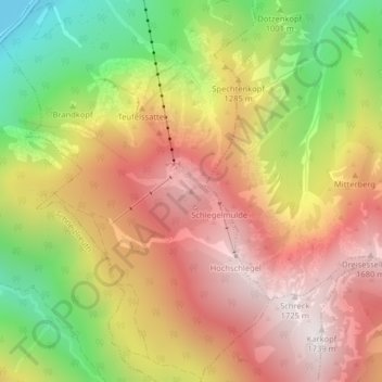
Name: Predigtstuhl topographic map, elevation, terrain.
Average elevation: 1,162 m
Minimum elevation: 480 m
Maximum elevation: 1,714 m
Other topographic maps
Click on a map to view its topography, its elevation and its terrain.
Thumsee
Deutschland > Bayern > Landkreis Berchtesgadener Land > Bad Reichenhall > Thumsee
Average elevation: 731 m
Thumsee
Deutschland > Bayern > Landkreis Berchtesgadener Land > Bad Reichenhall > Thumsee
Average elevation: 733 m