
Shire of Towong topographic map
Interactive map
Click on the map to display elevation.
About this map
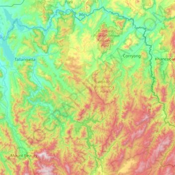
Name: Shire of Towong topographic map, elevation, terrain.
Location: Shire of Towong, Victoria, Australië (-36.81248 147.03139 -35.92865 148.22035)
Average elevation: 660 m
Minimum elevation: 159 m
Maximum elevation: 1,972 m
Other topographic maps
Click on a map to view its topography, its elevation and its terrain.
Blackburn South
Australië > Victoria > Melbourne
Blackburn South, Melbourne, City of Whitehorse, Victoria, 3130, Australië
Average elevation: 103 m
Phillip Island
Australië > Victoria > Ventnor
Phillip Island, Ventnor, Bass Coast Shire, Victoria, Australië
Average elevation: 5 m
Shire of Wellington
Shire of Wellington, Victoria, Australië
Average elevation: 331 m
Bakery Hill
Australië > Victoria > Ballarat
Bakery Hill, Ballarat, City of Ballarat, Grampians, Victoria, 3350, Australië
Average elevation: 437 m
Shepparton
Australië > Victoria > Shepparton
Shepparton, City of Greater Shepparton, Victoria, 3630, Australië
Average elevation: 115 m
Port Fairy
Australië > Victoria > Port Fairy
Port Fairy, Shire of Moyne, Barwon South West, Victoria, 3284, Australië
Average elevation: 3 m
Shepparton
Australië > Victoria > Shepparton
Shepparton, Currawa Rise, Dookie, Shepparton, City of Greater Shepparton, Hume, Victoria, 3630, Australië
Average elevation: 113 m
Little River
Little River, City of Wyndham, Barwon South West, Victoria, Australië
Average elevation: 7 m
Shire of Corangamite
Shire of Corangamite, Barwon South West, Victoria, Australië
Average elevation: 151 m
Mount Sabine
Mount Sabine, Shire of Colac Otway, Barwon South West, Victoria, Australië
Average elevation: 481 m
Shepparton
Australië > Victoria > Shepparton
Shepparton, City of Greater Shepparton, Hume, Victoria, 3630, Australië
Average elevation: 115 m
Mount Murphy
Mount Murphy, Shire of East Gippsland, Gippsland, Victoria, Australië
Average elevation: 1,198 m