Geolocate

Banyumanik topographic map

Click on the map to display elevation.

About this map

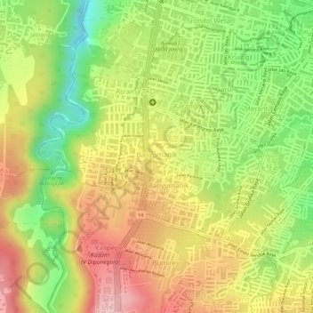
Name: Banyumanik topographic map, elevation, terrain.

Location: Banyumanik, Semarang, Central Java, Java, 50265, Indonesia (-7.08479 110.40193 -7.07036 110.42157)

Average elevation: 242 m

Minimum elevation: 131 m

Maximum elevation: 334 m

Other topographic maps

Click on a map to view its topography, its elevation and its terrain.

Kramas

Indonesia > Central Java > Semarang

Average elevation: 170 m

Ngaliyan

Indonesia > Central Java > Semarang

Average elevation: 125 m

Gajahmungkur

Indonesia > Central Java > Semarang

Average elevation: 64 m

Tembalang

Indonesia > Central Java > Semarang > Bulusan

Average elevation: 194 m

Ampelgading

Indonesia > Central Java > Semarang

Average elevation: 196 m

Tikung

Indonesia > Central Java > Semarang

Average elevation: 22 m

Candisari

Indonesia > Central Java > Semarang

Average elevation: 126 m

Tambakaji

Indonesia > Central Java > Semarang

Average elevation: 60 m

Gunungpati

Indonesia > Central Java > Semarang

Average elevation: 303 m

Gear up for your next adventure:

🔥Camping Stove - Portable stoves to cook outdoors with ease
Tent Footprint - Protect tent floor and increase durability
🧥Insulated Jacket - Keep warm in cold outdoor conditions
🧰Emergency Multi-Tool - Compact multi-tool for outdoor survival
Camping Groundsheet - Protect your tent from moisture and dirt

As an Amazon Associate, this site earns from qualifying purchases at no extra cost to you.