
Barnag topographic map
Interactive map
Click on the map to display elevation.
About this map
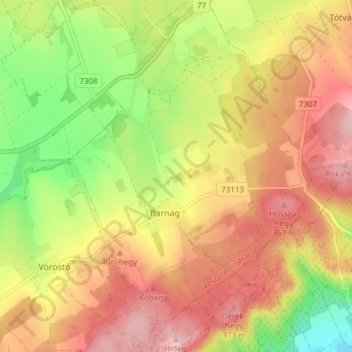
Name: Barnag topographic map, elevation, terrain.
Location: Barnag, Veszprémi járás, Veszprém, Transdanubia, Hungary (46.95923 17.72705 47.01078 17.78661)
Average elevation: 292 m
Minimum elevation: 185 m
Maximum elevation: 385 m
Other topographic maps
Click on a map to view its topography, its elevation and its terrain.
Badacsony
Hungary > Veszprém > Badacsonytomaj
Badacsony, Badacsonytomaj, Tapolcai járás, Veszprém, Central Transdanubia, Transdanubia, 8261, Hungary
Average elevation: 203 m
Balatonalmádi
Balatonalmádi, Balatonalmádi járás, Veszprém, Central Transdanubia, Transdanubia, Hungary
Average elevation: 153 m
Balatonudvari
Hungary > Veszprém > Balatonudvari
Balatonudvari, Balatonfüredi járás, Veszprém, Central Transdanubia, Transdanubia, 8242, Hungary
Average elevation: 119 m