
Make a donation
Gear up for your next adventure:
As an Amazon Associate, this site earns from qualifying purchases at no extra cost to you.
Rulle topographic map
Click on the map to display elevation.
Make a donation
Gear up for your next adventure:
As an Amazon Associate, this site earns from qualifying purchases at no extra cost to you.
Rulle
Mit der Buslinie 533, die täglich fährt und in der Regel einen 20- oder 40-Minuten-Takt hat, ist Rulle an den öffentlichen Personennahverkehr nach Osnabrück angebunden. Die Linie 533 fährt von Rulle (Apotheke) über Osnabrück-Haste und die Knollstraße zum Hauptbahnhof, dann zum Neumarkt und weiter bis Osnabrück-Berningshöhe. Außerdem gibt es weitere einzelne Verbindungen mit den Linien 511, 585, 586 nach Osnabrück, Wallenhorst, Icker und Evinghausen. Zuständig ist die Planungsgesellschaft Nahverkehr Osnabrück PlaNOS.
Make a donation
Gear up for your next adventure:
As an Amazon Associate, this site earns from qualifying purchases at no extra cost to you.
About this map
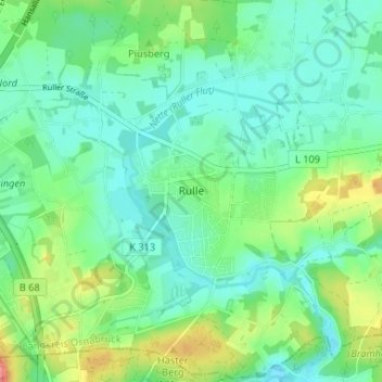
Name: Rulle topographic map, elevation, terrain.
Average elevation: 94 m
Minimum elevation: 71 m
Maximum elevation: 152 m
Make a donation
Gear up for your next adventure:
As an Amazon Associate, this site earns from qualifying purchases at no extra cost to you.