Geolocate

Cochaquillo topographic map

Click on the map to display elevation.

About this map

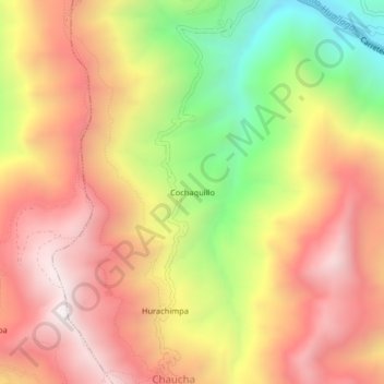
Name: Cochaquillo topographic map, elevation, terrain.

Location: Cochaquillo, Ambo, Huánuco, Perú (-10.21586 -76.22009 -10.17586 -76.18009)

Average elevation: 2,937 m

Minimum elevation: 2,195 m

Maximum elevation: 3,490 m

Gear up for your next adventure:

🔥Emergency Fire Starter - Reliable ignition source for all weather conditions
🥾Light Trekking Boots - Supportive boots for multi-day treks
🥾Waterproof Hiking Boots - Boots keeping your feet dry in wet conditions
🐕Hiking Dog Pack - Let your canine companion carry their own water and food
🧤Thermal Hiking Gloves - Grip-enhanced gloves for cold-weather altitude trekking

As an Amazon Associate, this site earns from qualifying purchases at no extra cost to you.