
Make a donation
Gear up for your next adventure:
As an Amazon Associate, this site earns from qualifying purchases at no extra cost to you.
Lobrigos (São Miguel) topographic map
Click on the map to display elevation.
Make a donation
Gear up for your next adventure:
As an Amazon Associate, this site earns from qualifying purchases at no extra cost to you.
About this map
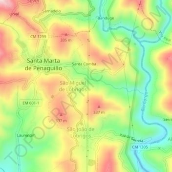
Name: Lobrigos (São Miguel) topographic map, elevation, terrain.
Average elevation: 231 m
Minimum elevation: 84 m
Maximum elevation: 395 m
Make a donation
Gear up for your next adventure:
As an Amazon Associate, this site earns from qualifying purchases at no extra cost to you.
Other topographic maps
Click on a map to view its topography, its elevation and its terrain.
Praia Fluvial de Fornelos
Portugal > Vila Real > Santa Marta de Penaguião > Barreiro
Average elevation: 416 m
Salgueiro
Portugal > Vila Real > Santa Marta de Penaguião > Alvações do Corgo
Average elevation: 287 m
Make a donation
Gear up for your next adventure:
As an Amazon Associate, this site earns from qualifying purchases at no extra cost to you.