
Make a donation
Gear up for your next adventure:
As an Amazon Associate, this site earns from qualifying purchases at no extra cost to you.
Thülen topographic map
Click on the map to display elevation.
Make a donation
Gear up for your next adventure:
As an Amazon Associate, this site earns from qualifying purchases at no extra cost to you.
Thülen
Thülen liegt im Hochsauerlandkreis nordöstlich von Brilon in den Briloner Höhen, nördlich der Alten Heeresstraße. Nachbarorte von Thülen sind Brilon, Nehden, Radlinghausen, Rösenbeck, Messinghausen, Hoppecke und Wülfte. Durch Thülen fließt die Schwelge.
Make a donation
Gear up for your next adventure:
As an Amazon Associate, this site earns from qualifying purchases at no extra cost to you.
About this map
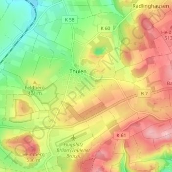
Name: Thülen topographic map, elevation, terrain.
Average elevation: 460 m
Minimum elevation: 377 m
Maximum elevation: 542 m
Make a donation
Gear up for your next adventure:
As an Amazon Associate, this site earns from qualifying purchases at no extra cost to you.