
Δήμος Ασπροπύργου topographic map
Interactive map
Click on the map to display elevation.
About this map
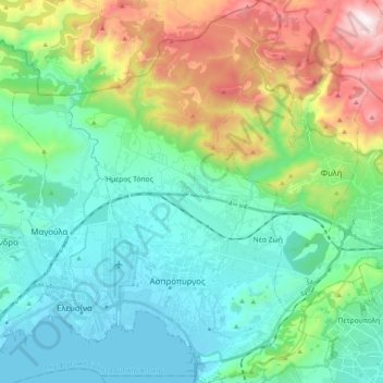
Name: Δήμος Ασπροπύργου topographic map, elevation, terrain.
Average elevation: 304 m
Minimum elevation: -3 m
Maximum elevation: 1,158 m
Other topographic maps
Click on a map to view its topography, its elevation and its terrain.
Δημοτική Ενότητα Ελευσίνος
Grèce > Attique > Περιφερειακή Ενότητα Δυτικής Αττικής
Δημοτική Ενότητα Ελευσίνος, Δήμος Ελευσίνας, Περιφερειακή Ενότητα Δυτικής Αττικής, Attique, 192 00, Grèce
Average elevation: 40 m