Geolocate

Warmian-Masurian Voivodeship topographic map

Interactive map

Click on the map to display elevation.

About this map

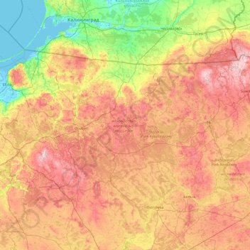
Name: Warmian-Masurian Voivodeship topographic map, elevation, terrain.

Location: Warmian-Masurian Voivodeship, Poland (53.13912 19.12764 54.45327 22.80614)

Average elevation: 105 m

Minimum elevation: -4 m

Maximum elevation: 296 m

Other topographic maps

Click on a map to view its topography, its elevation and its terrain.

Poraj

Poland > Łódź Voivodeship > Piotrków County

Average elevation: 225 m

Wroclaw

Poland > Lower Silesian Voivodeship > Wrocław > Wroclaw

Average elevation: 130 m

Niezdara

Poland > Tarnowskie Góry County

Average elevation: 286 m

Rysy

Poland > Lesser Poland Voivodeship > Tatra County > Brzegi

It is possible to reach the peak from the Slovak side, starting at Štrbské pleso and passing Chata pod Rysmi, a mountain chalet at an altitude of 2,250 m (7,380 ft). Between November 1 and June 15, the trail and chalet on the Slovak side are closed.

Average elevation: 2,005 m

Mosty

Poland > Łódź Voivodeship > Radomsko County

Average elevation: 215 m

Janów

Poland > Masovian Voivodeship > Radom County > Sławno

Average elevation: 192 m

Seligów

Poland > Łódzkie Voivodship > Łowicz County

Average elevation: 114 m

Laska

Poland > Pomeranian Voivodeship > Chojnice County

Average elevation: 140 m

Nieborowice

Poland > Gliwice County

Average elevation: 235 m

Wieżyca

Poland > Pomeranian Voivodeship > Kartuzy County > Kolano

Wieżyca (Kashubian Wieżëca, German Turmberg) is a hill located in northern Poland, in the historical region of Kashubia, some 40 kilometers southwest of Gdańsk. With elevation of 329 metres above sea level, it is the highest peak of central and northern Poland. Its top is covered by a forest, and the hill…

Average elevation: 247 m

Lubsza

Poland > Opole Voivodeship > Brzeg County

Average elevation: 137 m

Bródki

Poland > Lublin Voivodeship > Zamość County > Jacnia

Average elevation: 288 m

Gdansk

Poland > Pomeranian Voivodeship > Gdańsk > Gdansk

Average elevation: 49 m

Bojary

Poland > Masovian Voivodeship > Sokołów County > Bojary

Average elevation: 101 m

Banino

Poland > Pomeranian Voivodeship > Kartuzy County > Banino > Banino

Average elevation: 146 m

Poznań

Poland > Greater Poland Voivodeship > Poznań > Poznań

Average elevation: 86 m

Tatry

Poland > Lesser Poland Voivodeship > Tatra County > Zakopane

Average elevation: 1,647 m

Zabrze

Poland > Silesian Voivodeship > Zabrze > Zabrze

Average elevation: 266 m

Rzeszów

Poland > Subcarpathian Voivodeship > Rzeszów > Rzeszów

Average elevation: 254 m

Obłęże

Poland > Pomeranian Voivodeship > Obłęże

Average elevation: 78 m

Osuchów

Poland > Masovian Voivodeship > Osuchów

Average elevation: 199 m

Lubsza

Poland > Lubusz Voivodeship > Jasień

Average elevation: 84 m

772

Poland > Lower Silesian Voivodeship > Grzmiąca

Average elevation: 648 m

Zielony staw

Poland > Pomeranian Voivodeship > Gdansk

Average elevation: 104 m

Konin

Poland > Greater Poland Voivodeship > Konin

Average elevation: 100 m

Kanał Gliwicki

Poland > Silesian Voivodeship > Gliwice

Average elevation: 221 m

Przodkowo

Poland > Pomeranian Voivodeship > Przodkowo

Average elevation: 170 m