Geolocate

Croce topographic map

Click on the map to display elevation.

About this map

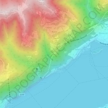
Name: Croce topographic map, elevation, terrain.

Location: Croce, Sala Comacina, Como, Lombardy, 22010, Italy (45.94392 9.13338 45.98392 9.17338)

Average elevation: 595 m

Minimum elevation: 183 m

Maximum elevation: 1,409 m

Gear up for your next adventure:

🥾Trail Hiking Socks - Comfortable socks to prevent blisters and fatigue
🥾Light Hiking Boots - Lightweight and comfortable boots for day hikes
🥾Mountain Hiking Boots - High-traction boots for rocky terrain
🧥Insulated Jacket - Keep warm in cold outdoor conditions
🧰Emergency Multi-Tool - Compact multi-tool for outdoor survival

As an Amazon Associate, this site earns from qualifying purchases at no extra cost to you.