
Make a donation
Gear up for your next adventure:
As an Amazon Associate, this site earns from qualifying purchases at no extra cost to you.
Croydon topographic map
Click on the map to display elevation.
Make a donation
Gear up for your next adventure:
As an Amazon Associate, this site earns from qualifying purchases at no extra cost to you.
About this map
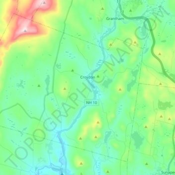
Name: Croydon topographic map, elevation, terrain.
Location: Croydon, Sullivan County, New Hampshire, United States (43.39440 -72.27186 43.49337 -72.11136)
Average elevation: 372 m
Minimum elevation: 228 m
Maximum elevation: 831 m
Make a donation
Gear up for your next adventure:
As an Amazon Associate, this site earns from qualifying purchases at no extra cost to you.
Other topographic maps
Click on a map to view its topography, its elevation and its terrain.
Kolelemook Lake
United States > New Hampshire > Sullivan County > Springfield
Average elevation: 463 m
North Charlestown
United States > New Hampshire > Sullivan County > Charlestown
Average elevation: 162 m
South Charlestown
United States > New Hampshire > Sullivan County > Charlestown
Average elevation: 153 m
Make a donation
Gear up for your next adventure:
As an Amazon Associate, this site earns from qualifying purchases at no extra cost to you.
Make a donation
Gear up for your next adventure:
As an Amazon Associate, this site earns from qualifying purchases at no extra cost to you.