
Make a donation
Gear up for your next adventure:
As an Amazon Associate, this site earns from qualifying purchases at no extra cost to you.
Otticha topographic map
Click on the map to display elevation.
Make a donation
Gear up for your next adventure:
As an Amazon Associate, this site earns from qualifying purchases at no extra cost to you.
About this map
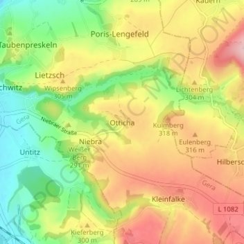
Name: Otticha topographic map, elevation, terrain.
Location: Otticha, Gera, Thüringen, 07551, Deutschland (50.80455 12.09996 50.84455 12.13996)
Average elevation: 282 m
Minimum elevation: 203 m
Maximum elevation: 366 m
Make a donation
Gear up for your next adventure:
As an Amazon Associate, this site earns from qualifying purchases at no extra cost to you.
Other topographic maps
Click on a map to view its topography, its elevation and its terrain.
Ferberturm
Deutschland > Thüringen > Gera
Der Ferberturm ist ein 21 Meter hoher Aussichtsturm auf der Ronneburger Höhe in der thüringischen Stadt Gera.
Average elevation: 248 m