
El Bolsón topographic map
Interactive map
Click on the map to display elevation.
About this map
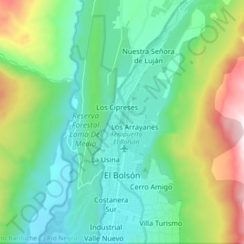
Name: El Bolsón topographic map, elevation, terrain.
Average elevation: 594 m
Minimum elevation: 243 m
Maximum elevation: 1,649 m
Other topographic maps
Click on a map to view its topography, its elevation and its terrain.
Costanera Sur
Argentina > Río Negro > Viedma
Costanera Sur, Viedma, Departamento Adolfo Alsina, Río Negro, Argentina
Average elevation: 9 m
Municipio de Cinco Saltos
Municipio de Cinco Saltos, Departamento General Roca, Río Negro, 8303, Argentina
Average elevation: 307 m
Lago Mascardi
Lago Mascardi, Ruta Provincial 81, Departamento Bariloche, Río Negro, Argentina
Average elevation: 1,090 m
SUPE
Argentina > Río Negro > General Roca
SUPE, General Roca, Departamento General Roca, Río Negro, Argentina
Average elevation: 244 m
Cerro Horqueta
Cerro Horqueta, Departamento Pilcaniyeu, Río Negro, Argentina
Average elevation: 1,105 m