Geolocate

Upshi topographic map

Click on the map to display elevation.

About this map

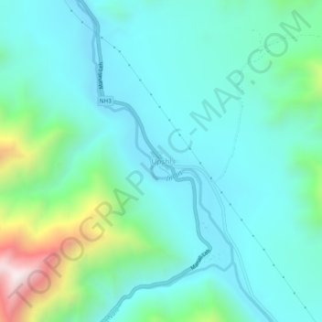
Name: Upshi topographic map, elevation, terrain.

Location: Upshi, Leh Tehsil, Leh District, Ladakh, India (33.81020 77.79363 33.85020 77.83363)

Average elevation: 3,586 m

Minimum elevation: 3,374 m

Maximum elevation: 4,436 m

Other topographic maps

Click on a map to view its topography, its elevation and its terrain.

Gear up for your next adventure:

🧰Survival Kit - Essential gear for emergencies in the wilderness
🐕Hiking Dog Pack - Let your canine companion carry their own water and food
🛶Waterproof Dry Bags - Keep electronics and clothes dry during river crossings
🥘Camping Cookware Set - Compact nesting pots and pans for trail cooking
🧤Rechargeable Heated Gloves - Extreme warmth for Canadian winter expeditions

As an Amazon Associate, this site earns from qualifying purchases at no extra cost to you.