
Ravenshoe topographic map
Interactive map
Click on the map to display elevation.
About this map
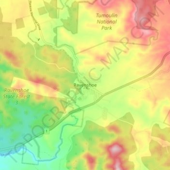
Name: Ravenshoe topographic map, elevation, terrain.
Location: Ravenshoe, Queensland, Australie (-17.64794 145.44194 -17.56794 145.52194)
Average elevation: 944 m
Minimum elevation: 755 m
Maximum elevation: 1,147 m
Other topographic maps
Click on a map to view its topography, its elevation and its terrain.
Millstream Falls National Park
Australie > Queensland > Ravenshoe
Millstream Falls National Park, Kennedy Highway, Ravenshoe, Queensland, Australie
Average elevation: 863 m