Geolocate

Laaber topographic map

Click on the map to display elevation.

About this map

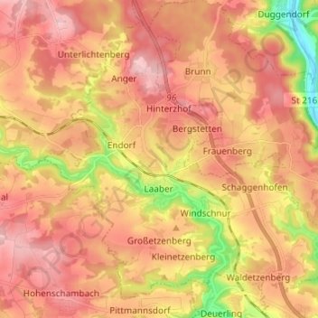
Name: Laaber topographic map, elevation, terrain.

Location: Laaber, Laaber (VGem), Landkreis Regensburg, Bavaria, Germany (49.03942 11.83960 49.10885 11.96086)

Average elevation: 467 m

Minimum elevation: 336 m

Maximum elevation: 553 m

Other topographic maps

Click on a map to view its topography, its elevation and its terrain.

Langenerling

Germany > Bavaria > Landkreis Regensburg

Average elevation: 355 m

Eggmühl

Germany > Bavaria > Landkreis Regensburg

Average elevation: 382 m

Wahlsdorf

Germany > Bavaria > Landkreis Regensburg

Average elevation: 435 m

Gear up for your next adventure:

🚲MTB Frame Bag - Carry tools and maps directly on your bicycle frame
🥾All-Terrain Hiking Boots - Versatile boots for varied hiking conditions
💧Collapsible Water Bottle - Space-saving water bottle for outdoor activities
🛶Kayak Dry Bag - Waterproof storage for kayaking adventures
💧Reusable Water Bottle - Durable water bottles for hydration on trails

As an Amazon Associate, this site earns from qualifying purchases at no extra cost to you.