
Make a donation
Gear up for your next adventure:
As an Amazon Associate, this site earns from qualifying purchases at no extra cost to you.
Decota topographic map
Click on the map to display elevation.
Make a donation
Gear up for your next adventure:
As an Amazon Associate, this site earns from qualifying purchases at no extra cost to you.
About this map
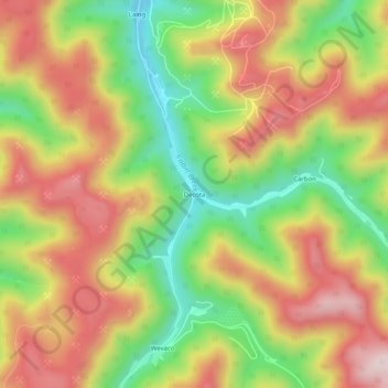
Name: Decota topographic map, elevation, terrain.
Location: Decota, Kanawha County, West Virginia, United States (37.99789 -81.44067 38.03789 -81.40067)
Average elevation: 547 m
Minimum elevation: 314 m
Maximum elevation: 768 m
Make a donation
Gear up for your next adventure:
As an Amazon Associate, this site earns from qualifying purchases at no extra cost to you.
Other topographic maps
Click on a map to view its topography, its elevation and its terrain.
Charleston
United States > West Virginia > Kanawha County
Charleston has a four-season humid subtropical climate (Köppen Cfa) with continental climate (Dfa) elements. Especially in winter, Charleston's average temperatures are warmer than the rest of the state, due to the city being west of the higher elevations. Spring is the most unpredictable season, and…
Average elevation: 264 m