
Make a donation
Gear up for your next adventure:
As an Amazon Associate, this site earns from qualifying purchases at no extra cost to you.
Ladakh topographic map
Click on the map to display elevation.
Make a donation
Gear up for your next adventure:
As an Amazon Associate, this site earns from qualifying purchases at no extra cost to you.
About this map
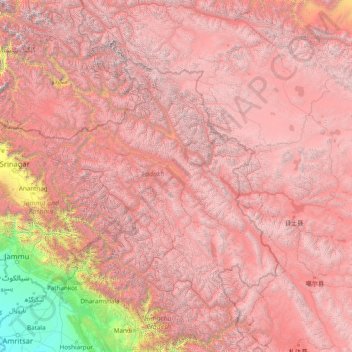
Name: Ladakh topographic map, elevation, terrain.
Location: Ladakh, Indien (31.38564 75.09686 36.50564 80.21686)
Average elevation: 4,221 m
Minimum elevation: 217 m
Maximum elevation: 7,778 m
Make a donation
Gear up for your next adventure:
As an Amazon Associate, this site earns from qualifying purchases at no extra cost to you.
Other topographic maps
Click on a map to view its topography, its elevation and its terrain.
Indus
Indien > Ladakh > Leh Tehsil
Der Indus entsteht im Transhimalaya im Autonomen Gebiet Tibet der Volksrepublik China in einer Höhe von ca. 5300 m aus den von Gletscherbächen gespeisten Seen Rexicuo und Zabu Tso nordöstlich des heiligen Berges Kailash. Er trägt in China den amtlichen Namen Sênggê Zangbo (chinesisch 森格藏布,…
Average elevation: 4,192 m
Make a donation
Gear up for your next adventure:
As an Amazon Associate, this site earns from qualifying purchases at no extra cost to you.