
Korha topographic map
Interactive map
Click on the map to display elevation.
About this map
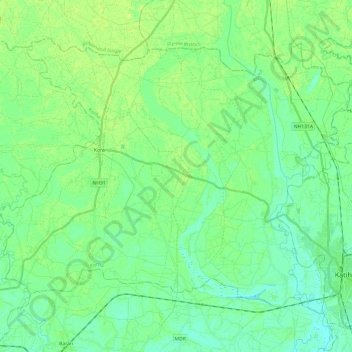
Name: Korha topographic map, elevation, terrain.
Location: Korha, Katihar, Bihar, Inde (25.51917 87.33084 25.68930 87.57159)
Average elevation: 34 m
Minimum elevation: 27 m
Maximum elevation: 42 m
Other topographic maps
Click on a map to view its topography, its elevation and its terrain.
Sahebpur Kamal
Inde > Bihar > Sahebpur Kamal
Sahebpur Kamal, Begusarai, Bihar, 851217, Inde
Average elevation: 40 m
Patna
Inde > Bihar > Patna Rural
Patna, Patna Rural, Patna District, Bihar, 800001, Inde
Average elevation: 51 m
Gaya
Inde > Bihar > Gaya Town C.D.Block
Gaya, Gaya Town C.D.Block, Gaya District, Bihar, 823001, Inde
Average elevation: 111 m
Bagmati River
Bagmati River, Sītāmarhi, Sitamarhi, Bihar, 843321, Inde
Average elevation: 422 m