
Make a donation
Gear up for your next adventure:
As an Amazon Associate, this site earns from qualifying purchases at no extra cost to you.
West Hartford topographic map
Click on the map to display elevation.
Make a donation
Gear up for your next adventure:
As an Amazon Associate, this site earns from qualifying purchases at no extra cost to you.
West Hartford
The west side of West Hartford is flanked by the Metacomet Ridge, a mountainous trap rock ridgeline that stretches from Long Island Sound to nearly the Vermont border. Notable features of the Metacomet Ridge in West Hartford include Talcott Mountain and a number of highland water reservoirs belonging to the Metropolitan District, which maintains watershed and recreation resources on the property. The 51-mile-long (82 km) Metacomet Trail traverses the ridge. The town's web site indicates that the highest point in town is 778 feet (237 m) above sea level on Talcott (Avon) Mountain. The altitude at Town Hall is 120 feet (37 m).
Make a donation
Gear up for your next adventure:
As an Amazon Associate, this site earns from qualifying purchases at no extra cost to you.
About this map
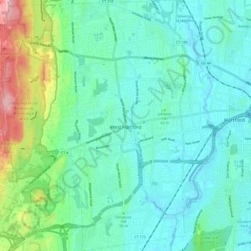
Name: West Hartford topographic map, elevation, terrain.
Average elevation: 60 m
Minimum elevation: 9 m
Maximum elevation: 250 m
Make a donation
Gear up for your next adventure:
As an Amazon Associate, this site earns from qualifying purchases at no extra cost to you.
Other topographic maps
Click on a map to view its topography, its elevation and its terrain.
West Suffield
United States > Connecticut > Capitol Planning Region > Suffield
Average elevation: 59 m
Plantsville
United States > Connecticut > Capitol Planning Region > Southington
Average elevation: 57 m
Four Corners
United States > Connecticut > Capitol Planning Region > Terramuggus
Average elevation: 143 m
Willington Hill
United States > Connecticut > Capitol Planning Region > Willington
Average elevation: 197 m
Make a donation
Gear up for your next adventure:
As an Amazon Associate, this site earns from qualifying purchases at no extra cost to you.
Griswoldville
United States > Connecticut > Capitol Planning Region > Wethersfield
Average elevation: 34 m
Make a donation
Gear up for your next adventure:
As an Amazon Associate, this site earns from qualifying purchases at no extra cost to you.
Chaffeeville
United States > Connecticut > Capitol Planning Region > Mansfield
Average elevation: 133 m
West District
United States > Connecticut > Capitol Planning Region > Farmington
Average elevation: 92 m
Talcott Mountain
United States > Connecticut > Capitol Planning Region > Bloomfield
Average elevation: 152 m
Make a donation
Gear up for your next adventure:
As an Amazon Associate, this site earns from qualifying purchases at no extra cost to you.
South Wethersfield
United States > Connecticut > Capitol Planning Region > Wethersfield > Griswoldville
Average elevation: 22 m
Buckingham
United States > Connecticut > Capitol Planning Region > Glastonbury
Average elevation: 131 m
North Coventry
United States > Connecticut > Capitol Planning Region > Coventry
Average elevation: 195 m
Make a donation
Gear up for your next adventure:
As an Amazon Associate, this site earns from qualifying purchases at no extra cost to you.
Bishop's Corner
United States > Connecticut > Capitol Planning Region > West Hartford
Average elevation: 47 m
Talcott Mountain
United States > Connecticut > Capitol Planning Region > Bloomfield
Average elevation: 152 m
Johnson Hill
United States > Connecticut > Capitol Planning Region > West Hartford
Average elevation: 34 m
Make a donation
Gear up for your next adventure:
As an Amazon Associate, this site earns from qualifying purchases at no extra cost to you.
Make a donation
Gear up for your next adventure:
As an Amazon Associate, this site earns from qualifying purchases at no extra cost to you.
Holcomb Farm
United States > Connecticut > Capitol Planning Region > Granby > West Granby
Average elevation: 116 m
Make a donation
Gear up for your next adventure:
As an Amazon Associate, this site earns from qualifying purchases at no extra cost to you.
Spoonville
United States > Connecticut > Capitol Planning Region > East Granby
Average elevation: 62 m
Stafford Springs
United States > Connecticut > Capitol Planning Region > Stafford
Average elevation: 200 m
Make a donation
Gear up for your next adventure:
As an Amazon Associate, this site earns from qualifying purchases at no extra cost to you.
Cottage Grove
United States > Connecticut > Capitol Planning Region > Bloomfield
Average elevation: 31 m
Barbara Drive
United States > Connecticut > Capitol Planning Region > Windsor Locks
Average elevation: 39 m
Make a donation
Gear up for your next adventure:
As an Amazon Associate, this site earns from qualifying purchases at no extra cost to you.