Geolocate

Barbate topographic map

Click on the map to display elevation.

About this map
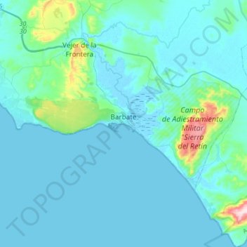
Name: Barbate topographic map, elevation, terrain.

Location: Barbate, La Janda, Cádiz, Andalusia, Spain (36.12725 -6.05471 36.24499 -5.78675)

Average elevation: 34 m

Minimum elevation: -3 m

Maximum elevation: 365 m

Other topographic maps

Click on a map to view its topography, its elevation and its terrain.

Zahara de los Atunes

Spain > Andalusia > La Janda > Barbate

Average elevation: 20 m

Cape Trafalgar

Spain > Andalusia > La Janda > Barbate

Average elevation: 2 m

Cape Trafalgar

Spain > Andalusia > La Janda > Barbate

Average elevation: 2 m

Cape Trafalgar

Spain > Andalusia > La Janda > Barbate

Average elevation: 2 m

Los Laganes

Spain > Andalusia > La Janda > Alcalá de los Gazules

Average elevation: 234 m

Zahara de los Atunes

Spain > Andalusia > La Janda > Barbate

Average elevation: 20 m

Cape Trafalgar

Spain > Andalusia > La Janda > Barbate

Average elevation: 2 m

Gear up for your next adventure:

🧰Multitool Knife - Compact and versatile tool for outdoor use
🦟Insect Repellent - Keep mosquitoes and black flies away in wooded areas
🥾Mountain Hiking Boots - High-traction boots for rocky terrain
🥾Light Trekking Boots - Supportive boots for multi-day treks
🧭GPS Tracker - Track your location in remote areas safely

As an Amazon Associate, this site earns from qualifying purchases at no extra cost to you.