
Make a donation
Gear up for your next adventure:
As an Amazon Associate, this site earns from qualifying purchases at no extra cost to you.
Cersay topographic map
Click on the map to display elevation.
Make a donation
Gear up for your next adventure:
As an Amazon Associate, this site earns from qualifying purchases at no extra cost to you.
About this map
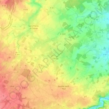
Name: Cersay topographic map, elevation, terrain.
Average elevation: 87 m
Minimum elevation: 50 m
Maximum elevation: 118 m
Make a donation
Gear up for your next adventure:
As an Amazon Associate, this site earns from qualifying purchases at no extra cost to you.
Other topographic maps
Click on a map to view its topography, its elevation and its terrain.
Le Pain Bénit
France > Nouvelle-Aquitaine > Deux-Sèvres > Val en Vignes > Le Pain Bénit
Average elevation: 96 m
La Maynie
France > Nouvelle-Aquitaine > Deux-Sèvres > Val en Vignes > La Maynie
Average elevation: 93 m
Make a donation
Gear up for your next adventure:
As an Amazon Associate, this site earns from qualifying purchases at no extra cost to you.