Geolocate

Sur topographic map

Click on the map to display elevation.

About this map

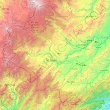
Name: Sur topographic map, elevation, terrain.

Location: Sur, Huila, Región Andina, Colombia (1.55547 -76.62426 2.27909 -75.82557)

Average elevation: 2,183 m

Minimum elevation: 386 m

Maximum elevation: 4,623 m

Other topographic maps

Click on a map to view its topography, its elevation and its terrain.

El Santo De San Jose

Colombia > Huila > Isnos

Average elevation: 1,830 m

Normandia

Colombia > Huila > Pitalito > Bruselas

Average elevation: 1,700 m

Hobo

Colombia > Huila > Hobo

Average elevation: 605 m

Santa Rita

Colombia > Huila > Pitalito

Average elevation: 1,592 m

Gigante

Colombia > Huila > Gigante

Average elevation: 862 m

De Betania

Colombia > Huila > Tarqui

Average elevation: 1,518 m

San Agustin

Colombia > Huila > San Agustín > San Agustin

Average elevation: 1,687 m

Desierto de la Tatacoa

Colombia > Huila > Villavieja

Average elevation: 448 m

Gear up for your next adventure:

🚲Handlebar Phone Mount - View topographic-map.com live while cycling
💡Compact LED Flashlight - Powerful and portable flashlight for outdoor use
🥾Trail Hiking Socks - Comfortable socks to prevent blisters and fatigue
🥾Mountaineering Boots - Supportive boots for climbing and high-altitude hiking
🧤Thermal Hiking Gloves - Grip-enhanced gloves for cold-weather altitude trekking

As an Amazon Associate, this site earns from qualifying purchases at no extra cost to you.