Geolocate

Durham topographic map

Click on the map to display elevation.

About this map

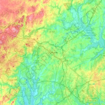
Name: Durham topographic map, elevation, terrain.

Location: Durham, Durham County, North Carolina, 27701, United States (35.83665 -79.06181 36.15665 -78.74181)

Average elevation: 119 m

Minimum elevation: 66 m

Maximum elevation: 238 m

Other topographic maps

Click on a map to view its topography, its elevation and its terrain.

Gear up for your next adventure:

🥾Light Hiking Boots - Lightweight and comfortable boots for day hikes
👟Trail Running Shoes - Agile footwear for fast-paced topographic exploration
🧭GPS Outdoor Watch - Smart watch for navigation and fitness tracking in nature
🪑Ultralight Camping Stool - Compact seating for rest stops during long hikes
🥾Light Trekking Boots - Supportive boots for multi-day treks

As an Amazon Associate, this site earns from qualifying purchases at no extra cost to you.