
Make a donation
Gear up for your next adventure:
As an Amazon Associate, this site earns from qualifying purchases at no extra cost to you.
Maglič topographic map
Click on the map to display elevation.
Make a donation
Gear up for your next adventure:
As an Amazon Associate, this site earns from qualifying purchases at no extra cost to you.
About this map
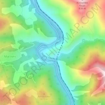
Name: Maglič topographic map, elevation, terrain.
Average elevation: 452 m
Minimum elevation: 241 m
Maximum elevation: 812 m
Make a donation
Gear up for your next adventure:
As an Amazon Associate, this site earns from qualifying purchases at no extra cost to you.
Other topographic maps
Click on a map to view its topography, its elevation and its terrain.
Stolovi
Serbia > Central Serbia > Raska Administrative District > Kraljevo City
Stolovi (Serbian Cyrillic: Столови) is a mountain in central Serbia, near the city of Kraljevo. Its highest peak Usovica has an elevation of 1,356 meters above sea level.
Average elevation: 1,059 m