
Make a donation
Gear up for your next adventure:
As an Amazon Associate, this site earns from qualifying purchases at no extra cost to you.
Bockhorn topographic map
Click on the map to display elevation.
Make a donation
Gear up for your next adventure:
As an Amazon Associate, this site earns from qualifying purchases at no extra cost to you.
Bockhorn
Das große Oldtimer- und Teilemarkt in Bockhorn findet jährlich rund um Pfingsten (Juni) statt, Höhepunkt der Oldtimermesse ist die Friesland-Rallye mit Oldtimern und Youngtimern. Jeweils am zweiten Septemberwochenende findet mit dem Bockhorner Markt die Hauptattraktion des Jahres statt.
Make a donation
Gear up for your next adventure:
As an Amazon Associate, this site earns from qualifying purchases at no extra cost to you.
About this map
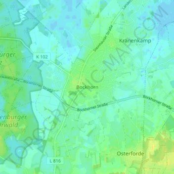
Name: Bockhorn topographic map, elevation, terrain.
Location: Bockhorn, Landkreis Friesland, Niedersachsen, 26345, Deutschland (53.37165 7.99612 53.41165 8.03612)
Average elevation: 6 m
Minimum elevation: -3 m
Maximum elevation: 18 m
Make a donation
Gear up for your next adventure:
As an Amazon Associate, this site earns from qualifying purchases at no extra cost to you.