
Make a donation
Gear up for your next adventure:
As an Amazon Associate, this site earns from qualifying purchases at no extra cost to you.
Sejangkung topographic map
Click on the map to display elevation.
Make a donation
Gear up for your next adventure:
As an Amazon Associate, this site earns from qualifying purchases at no extra cost to you.
Sejangkung
Sejangkung is a district in Sambas Regency, West Kalimantan, Indonesia. It is located on the western side of the island of Borneo, bordering Galing and Sajingan Besar to the north, Jagoi Babang and Seluas to the east, Subah and Sajad to the south, as well as Sambas and Teluk Keramat to the west. The district has an average elevation of 17 meters above the sea level. In the year 2010, the population of Sejangkung was 22,318.
Make a donation
Gear up for your next adventure:
As an Amazon Associate, this site earns from qualifying purchases at no extra cost to you.
About this map
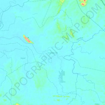
Name: Sejangkung topographic map, elevation, terrain.
Location: Sejangkung, Sambas, West Kalimantan, Kalimantan, Indonesia (1.24410 109.25328 1.54846 109.62557)
Average elevation: 17 m
Minimum elevation: 0 m
Maximum elevation: 435 m
Make a donation
Gear up for your next adventure:
As an Amazon Associate, this site earns from qualifying purchases at no extra cost to you.
Other topographic maps
Click on a map to view its topography, its elevation and its terrain.
Make a donation
Gear up for your next adventure:
As an Amazon Associate, this site earns from qualifying purchases at no extra cost to you.