
Make a donation
Gear up for your next adventure:
As an Amazon Associate, this site earns from qualifying purchases at no extra cost to you.
Mateus Leme topographic map
Click on the map to display elevation.
Make a donation
Gear up for your next adventure:
As an Amazon Associate, this site earns from qualifying purchases at no extra cost to you.
Mateus Leme
Mateus Leme limita-se ao sul com Itatiaiuçu pela Serra Azul, onde se localiza o ponto de altitude máxima do município, com 1.298 metros em relação ao nível do mar. O ponto de altitude mínima do município localiza-se no reservatório Serra Azul, no limite com o município de Juatuba, a 791 metros em relação ao nível do mar.
Make a donation
Gear up for your next adventure:
As an Amazon Associate, this site earns from qualifying purchases at no extra cost to you.
About this map
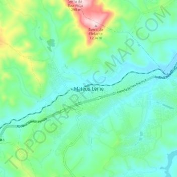
Name: Mateus Leme topographic map, elevation, terrain.
Average elevation: 866 m
Minimum elevation: 744 m
Maximum elevation: 1,269 m
Make a donation
Gear up for your next adventure:
As an Amazon Associate, this site earns from qualifying purchases at no extra cost to you.