
Make a donation
Gear up for your next adventure:
As an Amazon Associate, this site earns from qualifying purchases at no extra cost to you.
Western Macedonia topographic map
Click on the map to display elevation.
Make a donation
Gear up for your next adventure:
As an Amazon Associate, this site earns from qualifying purchases at no extra cost to you.
About this map
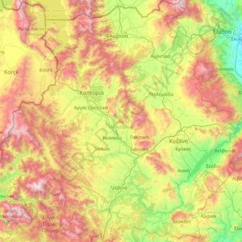
Name: Western Macedonia topographic map, elevation, terrain.
Location: Western Macedonia, Epirus and Western Macedonia, Greece (39.83036 20.77537 40.94346 22.19532)
Average elevation: 938 m
Minimum elevation: 26 m
Maximum elevation: 2,597 m
Make a donation
Gear up for your next adventure:
As an Amazon Associate, this site earns from qualifying purchases at no extra cost to you.
Other topographic maps
Click on a map to view its topography, its elevation and its terrain.
Florina
Greece > Epirus and Western Macedonia > Florina Regional Unit
Florina is one of the coldest towns in Greece, because of its elevation and geographic position. Heavy snowfalls, thick fog and below-freezing temperatures are common during the winter months, while the summers are mild. Under the Köppen climate classification, Florina has a humid subtropical climate (Cfa)…
Average elevation: 999 m