Geolocate

Saint-Pierre topographic map

Click on the map to display elevation.

About this map
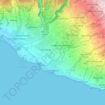
Name: Saint-Pierre topographic map, elevation, terrain.

Location: Saint-Pierre, Réunion, France (-21.36355 55.40380 -21.25439 55.60481)

Average elevation: 327 m

Minimum elevation: 0 m

Maximum elevation: 1,645 m

Other topographic maps

Click on a map to view its topography, its elevation and its terrain.
Boucan-Canot

France > Réunion > Saint-Paul

Average elevation: 41 m

Ravine-Glissante

France > Réunion > Sainte-Rose

Average elevation: 87 m

La Rivière des Galets

France > Réunion > Le Port

Average elevation: 106 m

Saint-Laurent

France > Réunion > La Possession

Average elevation: 126 m

Ruisseau Blanc

France > Réunion > Saint-Denis

Average elevation: 385 m

Grand Bassin

France > Réunion > Le Tampon

Average elevation: 1,179 m

La Plaine Chabrier

France > Réunion > Saint-Paul

Average elevation: 26 m

Hell-Bourg

France > Réunion

Average elevation: 1,132 m

Gear up for your next adventure:

🧤Rechargeable Heated Gloves - Extreme warmth for Canadian winter expeditions
💡Compact LED Flashlight - Powerful and portable flashlight for outdoor use
🥾Trail Running Shoes - Lightweight and durable shoes for trail running
🧦Hiking Liner Socks - Thin base layer to prevent friction and blisters
☕Camping Coffee Maker - Brew fresh coffee anywhere on the topographic map

As an Amazon Associate, this site earns from qualifying purchases at no extra cost to you.