Geolocate

Sandakphu topographic map

Click on the map to display elevation.

About this map

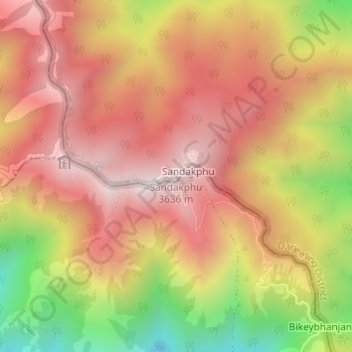
Name: Sandakphu topographic map, elevation, terrain.

Location: Sandakphu, Darjeeling Pulbazar, Darjeeling, West Bengal, India (27.10439 88.00043 27.10449 88.00053)

Average elevation: 3,285 m

Minimum elevation: 2,772 m

Maximum elevation: 3,617 m

Gear up for your next adventure:

🧢Hiking Sun Hat - Wide-brimmed protection for exposed mountain ridges
🧭GPS Handheld Device - Reliable GPS navigation for outdoor adventures
💧Hydration Pack - Hands-free hydration system for long hikes
Tent Footprint - Protect tent floor and increase durability
🕶️Polarized Sunglasses - Protect your eyes with durable polarized lenses

As an Amazon Associate, this site earns from qualifying purchases at no extra cost to you.