Geolocate

Aubusson topographic map

Click on the map to display elevation.

About this map

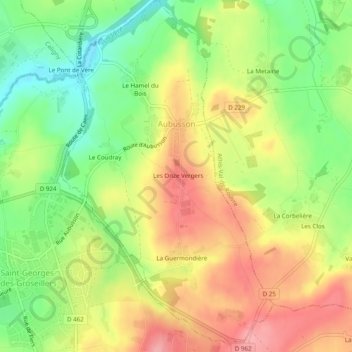
Name: Aubusson topographic map, elevation, terrain.

Location: Aubusson, Argentan, Orne, Normandy, Metropolitan France, 61100, France (48.76344 -0.56809 48.79555 -0.53871)

Average elevation: 223 m

Minimum elevation: 168 m

Maximum elevation: 277 m

Other topographic maps

Click on a map to view its topography, its elevation and its terrain.

Le Buisson Corblin

France > Normandy > Orne > Flers

Average elevation: 236 m

La Fouquerie

France > Normandy > Orne > Flers

Average elevation: 226 m

La Mare Jeannot

France > Normandy > Orne > Mantilly

Average elevation: 190 m

Moissy

France > Normandy > Orne > Gouffern en Auge > Chambois

Average elevation: 111 m

Gear up for your next adventure:

👟Trail Running Shoes - Agile footwear for fast-paced topographic exploration
🪜Heavy Duty Carabiners - Multi-use clips for securing gear to your backpack
🪑Ultralight Camping Stool - Compact seating for rest stops during long hikes
🕶️Polarized Sunglasses - Protect your eyes with durable polarized lenses
💡Portable Camping Lamp - Rechargeable lamp for campsite lighting

As an Amazon Associate, this site earns from qualifying purchases at no extra cost to you.