Geolocate

Yiling District topographic map

Click on the map to display elevation.

About this map

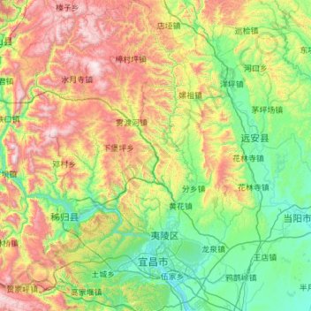
Name: Yiling District topographic map, elevation, terrain.

Location: Yiling District, Yichang, Hubei, China (30.54502 110.85005 31.47041 111.66185)

Average elevation: 596 m

Minimum elevation: 31 m

Maximum elevation: 1,972 m

Gear up for your next adventure:

💧Filtered Water Bottle - Safe drinking water on the go
🥾Trail Hiking Socks - Comfortable socks to prevent blisters and fatigue
🏃Hydration Running Vest - Carry water and maps close to your body for speed
🥫Freeze-Dried Meals - Lightweight, high-calorie nutrition for multi-day treks
🧢Hiking Sun Hat - Wide-brimmed protection for exposed mountain ridges

As an Amazon Associate, this site earns from qualifying purchases at no extra cost to you.