
Make a donation
Gear up for your next adventure:
As an Amazon Associate, this site earns from qualifying purchases at no extra cost to you.
Säntis topographic map
Click on the map to display elevation.
Make a donation
Gear up for your next adventure:
As an Amazon Associate, this site earns from qualifying purchases at no extra cost to you.
Säntis
Der Säntis steht in den nordwestlichen Alpen (Appenzeller Alpen) im Alpstein, knapp zehn Kilometer (Luftlinie) südsüdwestlich von Appenzell. Auf dem Säntis treffen drei Kantone zusammen, Appenzell Ausserrhoden (Gemeinde Hundwil), Appenzell Innerrhoden (Bezirk Schwende-Rüte) und St. Gallen (Gemeinde Wildhaus-Alt St. Johann im Toggenburg). Obwohl sein Gipfel nur 2502 m über dem Meer liegt, steht er durch die tiefe Abtrennung der Appenzeller Alpen nach seiner Schartenhöhe von 2015 m an dreizehnter Stelle in den Alpen und auf Rang 29 in Europa.
Make a donation
Gear up for your next adventure:
As an Amazon Associate, this site earns from qualifying purchases at no extra cost to you.
About this map
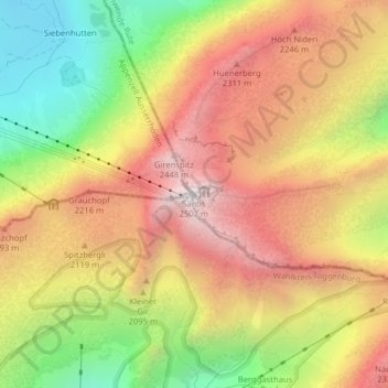
Name: Säntis topographic map, elevation, terrain.
Average elevation: 1,933 m
Minimum elevation: 1,298 m
Maximum elevation: 2,480 m
Make a donation
Gear up for your next adventure:
As an Amazon Associate, this site earns from qualifying purchases at no extra cost to you.