Geolocate

Casma topographic map

Click on the map to display elevation.

About this map

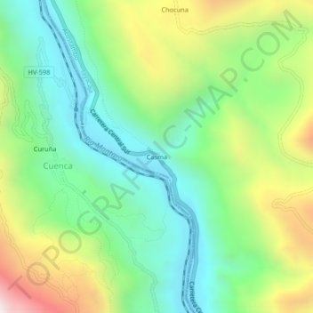
Name: Casma topographic map, elevation, terrain.

Location: Casma, Acostambo, Tayacaja, Huancavelica, Perú (-12.45208 -75.04568 -12.41208 -75.00568)

Average elevation: 3,306 m

Minimum elevation: 2,903 m

Maximum elevation: 4,063 m

Gear up for your next adventure:

🎒Backpack Rain Cover - External shield to keep your entire pack dry
🚑Survival Whistle - Signal for help across long distances in mountains
🧢Outdoor Cap - Protective cap for sun and rain during hikes
🧤Insulated Winter Gloves - Heavy-duty protection for sub-zero Canadian adventures
🧭GPS Tracker - Track your location in remote areas safely

As an Amazon Associate, this site earns from qualifying purchases at no extra cost to you.