
Kołobrzeg topographic map
Interactive map
Click on the map to display elevation.
About this map
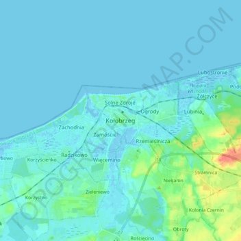
Name: Kołobrzeg topographic map, elevation, terrain.
Average elevation: 5 m
Minimum elevation: -3 m
Maximum elevation: 43 m
Other topographic maps
Click on a map to view its topography, its elevation and its terrain.
Siemyśl
Poland > West Pomeranian Voivodeship > Colberg County
Siemyśl, gmina Siemyśl, Colberg County, West Pomeranian Voivodeship, 78-123, Poland
Average elevation: 34 m
Charzyno
Poland > West Pomeranian Voivodeship > Colberg County
Charzyno, gmina Siemyśl, Colberg County, West Pomeranian Voivodeship, 78-122, Poland
Average elevation: 28 m
Bardy
Poland > West Pomeranian Voivodeship > Colberg County
Bardy, gmina Dygowo, Colberg County, West Pomeranian Voivodeship, 78-113, Poland
Average elevation: 32 m
Kołobrzeg
Poland > West Pomeranian Voivodeship > Colberg County > Kołobrzeg
Kołobrzeg, Colberg County, West Pomeranian Voivodeship, 78-100, Poland
Average elevation: 5 m