Geolocate

Belén de Umbría topographic map

Click on the map to display elevation.

Belén de Umbría

El Municipio tiene una extensión de 182.42 km² en donde el 60% es topografía ondulada el 5% es plana y el 35% es quebrada.

Wikipedia (CC-BY-SA 3.0)

About this map

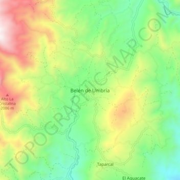
Name: Belén de Umbría topographic map, elevation, terrain.

Location: Belén de Umbría, Vertiente Occidental, Risaralda, RAP Eje Cafetero, Colombia (5.16091 -75.90899 5.24091 -75.82899)

Average elevation: 1,571 m

Minimum elevation: 1,071 m

Maximum elevation: 2,388 m

Gear up for your next adventure:

🩹Moleskin Blister Pads - Direct protection for painful foot pressure points
🥾Lightweight Hiking Shoes - Comfortable shoes for day hikes
🧥Waterproof Hiking Jacket - Protect yourself from rain and wind while hiking
🧦Thermal Socks - Warm socks for winter hiking or camping
🛶Kayak Dry Bag - Waterproof storage for kayaking adventures

As an Amazon Associate, this site earns from qualifying purchases at no extra cost to you.