
Make a donation
Gear up for your next adventure:
As an Amazon Associate, this site earns from qualifying purchases at no extra cost to you.
Bellwood topographic map
Click on the map to display elevation.
Make a donation
Gear up for your next adventure:
As an Amazon Associate, this site earns from qualifying purchases at no extra cost to you.
About this map
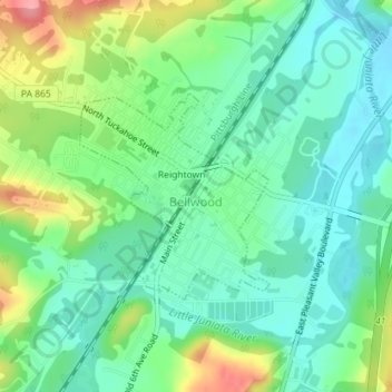
Name: Bellwood topographic map, elevation, terrain.
Location: Bellwood, Blair County, Pennsylvania, 16617, United States (40.59381 -78.34322 40.60808 -78.32595)
Average elevation: 333 m
Minimum elevation: 302 m
Maximum elevation: 398 m
Make a donation
Gear up for your next adventure:
As an Amazon Associate, this site earns from qualifying purchases at no extra cost to you.
Other topographic maps
Click on a map to view its topography, its elevation and its terrain.
Yellow Spring
United States > Pennsylvania > Blair County > Catharine Township
Average elevation: 358 m
Make a donation
Gear up for your next adventure:
As an Amazon Associate, this site earns from qualifying purchases at no extra cost to you.