
Santa Rosa Island topographic map
Click on the map to display elevation.
About this map
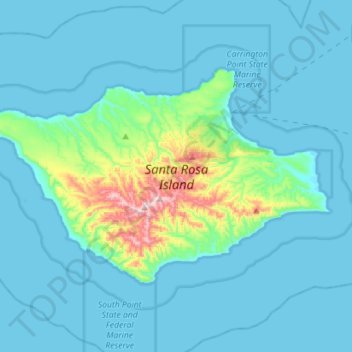
Name: Santa Rosa Island topographic map, elevation, terrain.
Average elevation: 51 m
Minimum elevation: -1 m
Maximum elevation: 478 m
Other topographic maps
Click on a map to view its topography, its elevation and its terrain.
Vandenberg Village
United States > California > Santa Barbara County > Lompoc
Average elevation: 132 m
North Santa Maria
United States > California > Santa Barbara County > Santa Maria
Average elevation: 65 m
Jalama Beach County Park
United States > California > Santa Barbara County > Jalama
Average elevation: 40 m
North Santa Maria
United States > California > Santa Barbara County > Santa Maria
Average elevation: 65 m
Shoreline Park
United States > California > Santa Barbara County > Santa Barbara
Average elevation: 21 m
Las Positas Meadows
United States > California > Santa Barbara County > Santa Barbara
Average elevation: 66 m