Geolocate

Khonoma topographic map

Click on the map to display elevation.

About this map

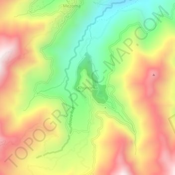
Name: Khonoma topographic map, elevation, terrain.

Location: Khonoma, Sechu-Zubza, Kohima, Nagaland, 797002, India (25.63429 94.00201 25.67429 94.04201)

Average elevation: 1,627 m

Minimum elevation: 1,144 m

Maximum elevation: 2,122 m

Other topographic maps

Click on a map to view its topography, its elevation and its terrain.

Sechu-Zubza

India > Nagaland > Sechu-Zubza

Average elevation: 1,443 m

Gear up for your next adventure:

🥾Light Hiking Boots - Lightweight and comfortable boots for day hikes
💧Collapsible Water Bottle - Space-saving water bottle for outdoor activities
Camping Groundsheet - Protect your tent from moisture and dirt
🥾Hiking Shoes - Durable and comfortable shoes for trail hiking
🥾All-Terrain Hiking Boots - Versatile boots for varied hiking conditions

As an Amazon Associate, this site earns from qualifying purchases at no extra cost to you.