
Findlay Creek topographic map
Interactive map
Click on the map to display elevation.
About this map
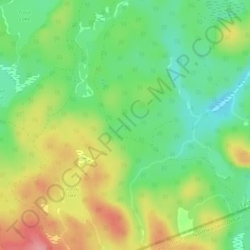
Name: Findlay Creek topographic map, elevation, terrain.
Average elevation: 265 m
Minimum elevation: 220 m
Maximum elevation: 325 m
Other topographic maps
Click on a map to view its topography, its elevation and its terrain.
Bissett Creek
Canada > Ontario > Head, Clara and Maria
Bissett Creek, Head, Clara and Maria, Renfrew County, Eastern Ontario, Ontario, Canada
Average elevation: 191 m
Stoney Lake
Canada > Ontario > Head, Clara and Maria
Stoney Lake, Bissett Creek Road, Head, Clara and Maria, Renfrew County, Ontario, Canada
Average elevation: 281 m
Head
Canada > Ontario > Head, Clara and Maria
Head, Chokecherry Lane, Head, Clara and Maria, Renfrew County, Eastern Ontario, Ontario, K0J 2K0, Canada
Average elevation: 238 m
Hogsback Lake
Canada > Ontario > Head, Clara and Maria
Hogsback Lake, Ashport, Head, Clara and Maria, Renfrew County, Ontario, Canada
Average elevation: 255 m