
Thank you for supporting this site ❤️
Make a donation
Make a donation
Gear up for your next adventure:
As an Amazon Associate, this site earns from qualifying purchases at no extra cost to you.
Cochonville topographic map
Click on the map to display elevation.
Thank you for supporting this site ❤️
Make a donation
Make a donation
Gear up for your next adventure:
As an Amazon Associate, this site earns from qualifying purchases at no extra cost to you.
About this map
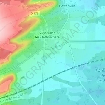
Name: Cochonville topographic map, elevation, terrain.
Average elevation: 270 m
Minimum elevation: 227 m
Maximum elevation: 406 m
Thank you for supporting this site ❤️
Make a donation
Make a donation
Gear up for your next adventure:
As an Amazon Associate, this site earns from qualifying purchases at no extra cost to you.
Other topographic maps
Click on a map to view its topography, its elevation and its terrain.
Hattonchâtel
France > Grand Est > Meuse > Vigneulles-lès-Hattonchâtel
Le village est situé sur un éperon rocheux à une altitude de 355 m, et domine de 80 m la plaine de la Woëvre et le lac de Madine.
Average elevation: 327 m