Geolocate

Rappocini topographic map

Click on the map to display elevation.

About this map

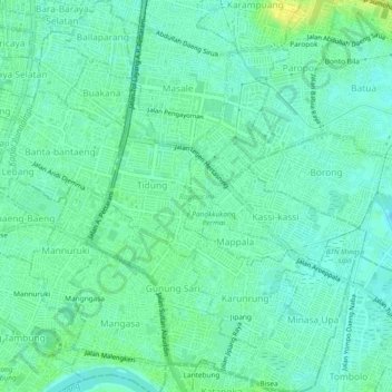
Name: Rappocini topographic map, elevation, terrain.

Location: Rappocini, Makassar, South Sulawesi, Sulawesi, Indonesia (-5.19196 119.42264 -5.14521 119.46493)

Average elevation: 7 m

Minimum elevation: 0 m

Maximum elevation: 19 m

Other topographic maps

Click on a map to view its topography, its elevation and its terrain.

Tidung Mariolo

Indonesia > South Sulawesi > Makassar > Tidung

Average elevation: 7 m

Gear up for your next adventure:

🦌Outdoor Trail Camera - Monitor wildlife activity near your favorite spots
🔨Vehicle Emergency Tool - Safety tool for remote road trips to trailheads
🥾Waterproof Hiking Boots - Essential footwear for rugged terrain and wet Canadian trails
🧼Travel Hand Sanitizer - Keep hands clean when water is scarce
🥾Hiking Shorts - Breathable shorts suitable for summer hikes

As an Amazon Associate, this site earns from qualifying purchases at no extra cost to you.