Geolocate

Cerro Cono topographic map

Click on the map to display elevation.

About this map

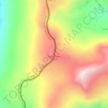
Name: Cerro Cono topographic map, elevation, terrain.

Location: Cerro Cono, O’Higgins, Provincia de Capitán Prat, Región Aysén del General Carlos Ibáñez del Campo, Chile (-48.04223 -72.42812 -48.04213 -72.42802)

Average elevation: 1,403 m

Minimum elevation: 1,010 m

Maximum elevation: 1,764 m

Other topographic maps

Click on a map to view its topography, its elevation and its terrain.

Gear up for your next adventure:

🎒Fully Waterproof Backpack - Total protection for photography gear and electronics
🧼Biodegradable Camp Soap - Environmentally friendly cleaning for gear and body
🌬️Windproof Camp Stove - Efficient cooking even on exposed mountain peaks
Tent Footprint - Protect tent floor and increase durability
🪜Heavy Duty Carabiners - Multi-use clips for securing gear to your backpack

As an Amazon Associate, this site earns from qualifying purchases at no extra cost to you.