Geolocate

Vantem topographic map

Click on the map to display elevation.

About this map

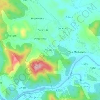
Name: Vantem topographic map, elevation, terrain.

Location: Vantem, Satari, North Goa, Goa, India (15.46458 74.07416 15.50458 74.11416)

Average elevation: 55 m

Minimum elevation: 1 m

Maximum elevation: 215 m

Other topographic maps

Click on a map to view its topography, its elevation and its terrain.

Mhadei Wildlife Sanctuary

India > Goa > Satari

Average elevation: 364 m

Surla

India > Goa > Satari > Nanorem

Average elevation: 384 m

Mhadei Wildlife Sanctuary

India > Goa > Satari > Caranzol

Average elevation: 415 m

Gear up for your next adventure:

Lightweight Camping Tent - Portable shelter optimized for Canadian backcountry camping
🦟Insect Repellent - Keep mosquitoes and black flies away in wooded areas
🎒Hiking Daypack - Lightweight and durable backpacks for day trips and excursions
🥾Trail Running Boots - Durable shoes designed for trail running
💡LED Headlamp - Hands-free illumination for night hiking and camping

As an Amazon Associate, this site earns from qualifying purchases at no extra cost to you.