Geolocate

Tlalpexco topographic map

Click on the map to display elevation.

About this map

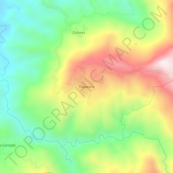
Name: Tlalpexco topographic map, elevation, terrain.

Location: Tlalpexco, Teloloapan, Guerrero, Mexico (18.48361 -100.01861 18.52361 -99.97861)

Average elevation: 1,032 m

Minimum elevation: 692 m

Maximum elevation: 1,508 m

Gear up for your next adventure:

🥾Trail Hiking Socks - Comfortable socks to prevent blisters and fatigue
🧴Bear Spray Holster - Quick-access carry for essential Canadian wilderness safety
🧰Survival Kit - Essential gear for emergencies in the wilderness
🧢Outdoor Cap - Protective cap for sun and rain during hikes
🐕Hiking Dog Pack - Let your canine companion carry their own water and food

As an Amazon Associate, this site earns from qualifying purchases at no extra cost to you.