Geolocate

Mabini topographic map

Click on the map to display elevation.

About this map

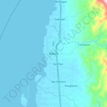
Name: Mabini topographic map, elevation, terrain.

Location: Mabini, Davao de Oro, Davao Region, 8807, Philippines (7.26845 125.81342 7.34845 125.89342)

Average elevation: 53 m

Minimum elevation: 0 m

Maximum elevation: 629 m

Other topographic maps

Click on a map to view its topography, its elevation and its terrain.

Laak

Philippines > Davao de Oro

Average elevation: 169 m

New Bataan

Philippines > Davao de Oro

Average elevation: 749 m

Kopiat Island

Philippines > Davao de Oro > Mabini

Average elevation: 2 m

New Bataan

Philippines > Davao de Oro

Average elevation: 749 m

Bega River

Philippines > Davao de Oro > Laak > Ferdinand

Average elevation: 89 m

Cateel River

Philippines > Davao de Oro > New Bataan

Average elevation: 586 m

Gear up for your next adventure:

🧥Waterproof Hiking Jacket - Protect yourself from rain and wind while hiking
🥾Hiking Leggings - Comfortable leggings for outdoor activities
🎒Backpack Rain Cover - External shield to keep your entire pack dry
🔥Emergency Fire Starter - Reliable ignition source for all weather conditions
Bushcraft Tarp - Versatile emergency shelter or gear protection

As an Amazon Associate, this site earns from qualifying purchases at no extra cost to you.