Geolocate

Botta topographic map

Click on the map to display elevation.

About this map

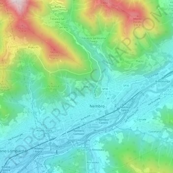
Name: Botta topographic map, elevation, terrain.

Location: Botta, Nembro, Bergamo, Lombardia, 24027, Italia (45.72844 9.73577 45.76844 9.77577)

Average elevation: 479 m

Minimum elevation: 273 m

Maximum elevation: 1,027 m

Gear up for your next adventure:

Bushcraft Tarp - Versatile emergency shelter or gear protection
🥫Freeze-Dried Meals - Lightweight, high-calorie nutrition for multi-day treks
🥾Waterproof Hiking Boots - Essential footwear for rugged terrain and wet Canadian trails
🥾Lightweight Hiking Boots - Boots for comfort and mobility on long hikes
🧥Waterproof Hiking Jacket - Protect yourself from rain and wind while hiking

As an Amazon Associate, this site earns from qualifying purchases at no extra cost to you.